By Morf Morford, Tacoma Daily Index
Mt. Rainier is not erupting
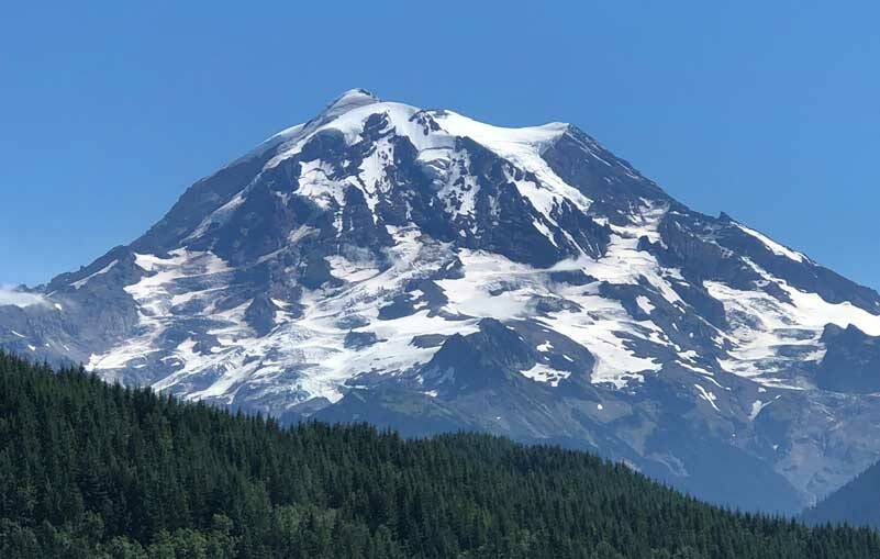
A local daily paper announced that, in fact Mt. Rainier is not erupting.
There was some unusual cloud activity around and above the mountain the first full week in September.
Maybe it’s just me, but somehow assurances that the mountain is, in fact NOT erupting do not comfort me very much.
It reminds me to much of the old story of how to get people to think about elephants; tell them NOT to think about elephants.
Do not think about recessions. Or pandemics. Or crime. Or homelessness. Or the economy. Or the general mood and tenor of the world right now. You weren’t going to sleep tonight anyway, were you?
No seismic activity
It turns out that volcanic activity cannot be seen – it can only be felt.
Whatever the source of the steam-vent release looking cloud formation, it does not count as volcanic unless it is accompanied by underlying activity, and, for better or worse, we did not see it. This time.
But we will.
The mountain defines us
Up close or in the distance, the mountain, as most locals call it, defines us as a region. It dominates our landscape, our identity and our conversations.
And our emergency planning time and budgets.
It’s on our license plates and our Washington state quarters.
What is likely to happen to Tacoma, Seattle and surrounding areas when Mount Rainier finally does erupt?
It depends.
But whenever it does happen, it won’t be a good day for those of us who live within sight of it.
And for those who live far beyond.
The damage from a Rainier eruption has a lot to do with the time of year, time of day and about a dozen other variables.
The mountain has erupted before
Volcanic eruptions are not rare around here. Mount St. Helens erupted in 1980; Lassen Peak in Northern California erupted in 1915. And the mountain we all know has erupted many times.
The most recent lava flows have been to the east, the north and south.
In other words, the western wall, the side facing Tacoma and most of Pierce County, is the oldest, and most brittle – and therefore the side most likely to fail.
The heat, source and velocity of lava combined with the amount of snow and ice will dictate how severely the eruption will hit us.
But one thing is certain – someday it will erupt and whatever comes our way will be very hot, and would melt any ice and snow.
And the amount of ice and snow on the surface of the mountain will dictate how massive and destructive our property and environmental impact will be.
When steaming lava flows encounter steep slopes and make avalanches of hot rocks and gas that are hurtling down the mountain at speeds approaching 100 miles per hour, there won’t be any out-running the flow of ice and snow melt. And nothing will stop it.
The lava is expected to stop flowing somewhere near the boundaries of the national park. But the water it would melt would create a much bigger hazard: a flash flood that would look like concrete in motion and swallow or engulf any and every thing in its path.
The two-dollar word for this unstoppable gush of ice, snow, rock and timber-infused mudflow is lahar.
And it would be loud. Like a jet coming in for a landing in your bedroom. Or an out-of-control freight train barreling anywhere gravity and momentum would take it.
If you’ve travelled through Orting or Puyallup, you’ve probably seen the lahar evacuation signs. Orting is built on historic lahar deposits about thirty feet (10 meters) deep. And there will be more to come.
Scientists say residents of Orting should have adequate warning to respond before an eruption – maybe a week or two.
40 minutes warning
But just in case, there’s a backup plan, a siren that gives people in Orting about 40 minutes warning before the lahar hits.
No one knows how big a lahar would be that we’d get from Mount Rainier – or how far it would travel.
But it would more than likely fill the south Puget Sound basin – which would include the Port of Tacoma, much of downtown Tacoma and, of course, I-5.
And, would cut off essentially all transportation and communication between Tacoma (and points south) and Seattle (and all points north).
There’s no alternate route, as we all know, north and south, around the mountain.
If the mountain has a major eruption, Tacoma and Pierce County will experience immediate and major shortages of food and supplies.
Including water and power.
Many of Tacoma’s hydroelectric dams and water sources are in lahar zones.
Besides those few Cascade passes that might remain open, (some close seasonally) the area north of the mountain would be cut off entirely (and indefinitely) from the rest of the country.
Be prepared
There are many things we can do to be, to some degree, prepared for the inevitable.
One option is to sign up for Pierce County’s alert system. You can opt to receive emergency alerts by phone, by text, and via several email addresses.
Remember that disaster responders may not be able to reach you immediately. Carry an emergency kit with water for four days in your car.
You will need a safe place to reunite with family in the event that you become separated. Have some kind of a agreed-upon reunification plan in place.
You can watch a National Geographic documentary from 2016 on what might happen if our mountain does start moving.


